“Maps are not impartial reference objects, but rather instruments of communication, persuasion, and power. Like paintings, they express a point of view. By connecting us to a reality that could not exist in the absence of maps–a world of property lines and voting rights, taxation districts and enterprise zones–they embody and project the interests of their creators.” (Wood, 2010)
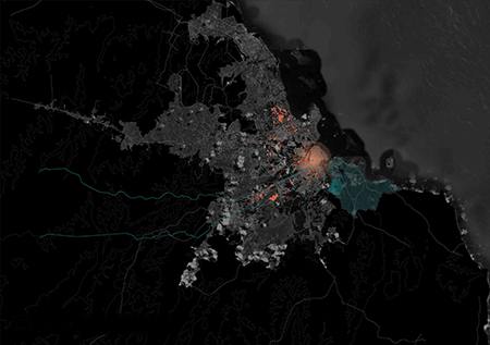
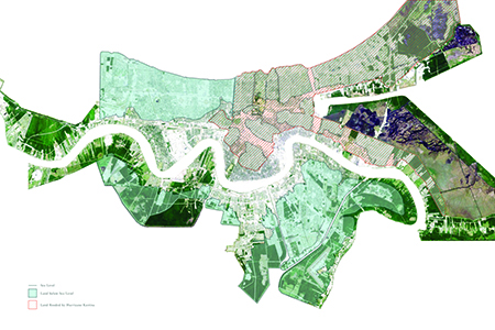
At its most primal level, a map is a cartographic instrument used to codify and convey territories, forces and flows. The art of map making is thus concerned with visually communicating unseen (or not easily seen) forces of demarcation. By nature, territories are simultaneously inclusive and exclusive, a political exercise.
The approaches presented in this exhibit offer urban design a long-overdue lens in the depiction of the contemporary city. They link urban design with the geological and geographic, the regional and the territorial, to engage unseen dynamics of cities. The mapped grounds of these cities provide current design and planning practice with an analytical and projective, precise yet speculative symbolic language to describe existing and imagined cities and the issues at hand.
Taken together, they question established modes of representation and their underlining assumptions about human habitation. They serve as provocative understandings of cities and the unseen forces that govern them. This collection begins to demonstrate that map making and city making are in fact inseparable and visionary.
JANUARY 21, 2015
6:00 – 8:00 PM
OPENING RECEPTION
Featuring discussions with curator, Dr. Shelagh McCartney, and five map designers from the exhibit. The speakers will address visualizing the urban imaginary, and provoke guests, through discussions of map creation, to reconsider how they view and experience cities through urban design. The discussion builds upon a series of studies and investigations by Dr. Shelagh McCartney and students at both Carleton and Ryerson University that identify variations in modes of the practice of mapping and consider moments of overlap between them.
FEBRUARY 4, 2015
6:00 – 8:00 PM
PANEL DISCUSSION
+city lab, the experimental research and design practice founded by Shelagh McCartney in 2012, focuses on contemporary approaches to city and open territory design resulting from rapid urbanization. The +city lab research seeks to nurture both scholarly and applied research at the intersections of architecture, landscape, and urbanism at various scales.
+city lab will host lectures by Talia Dorsey (The Commons/U Montreal), Lola Shepard (Lateral Office/U Waterloo) and John van Nostrand (planningAlliance) in conversation with Dr. Shelagh McCartney (+city lab/Ryerson). The panel will examine the role of mapping urban landscapes and their cultural and disciplinary contexts, by bringing together different realist-based work in an effort to identify modes of thought gained by empirical urbanisms of the recent past.
Curated by:
Dr. Shelagh McCartney Ryerson University and +city lab